Dry Spots in Midwest to See Heavy Rain
We have seen some spots in the Midwest get a little too dry lately; but those same areas should anticipate some potential heavy rainfall during the next week or so.

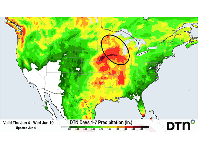
Heavy rainfall is forecast for some areas that have recently been dry in the Midwest (circled). (DTN graphic)
There’s been a lot of talk about how wet it has been this spring across the Midwest. Largely, that has been true. Drought areas that were spread across the region to start the spring were wiped out and some areas have dealt with flooding being more of an issue than dryness. But during the last couple weeks, drier spots have been showing up in portions of the region. Luckily for those same spots, the forecast for the next week shows potential for some heavy rain.
At the beginning of spring, drought covered large sections of Missouri, Illinois, eastern Iowa, Indiana and northwest Ohio. But a very active pattern in March and April essentially eliminated all that drought. However, on May 19, the U.S. Drought Monitor brought back a section of northeastern Illinois into the abnormal dryness category, D0. During the last two weeks, that small section has grown to extend through the northern half of Illinois, far northeastern Missouri, far northwestern Indiana, and much of Iowa, Wisconsin, and Minnesota.
Some small areas of D1, moderate drought, have been depicted over northern Illinois, southern Wisconsin, and along the Minnesota-Wisconsin border near La Crosse. You can find the most recent U.S. Drought Monitor map here: https://droughtmonitor.unl.edu/.
The 30-day rainfall amounts have been somewhere in the 50% or below-normal range, even though 60-day totals are above normal in some of these same areas, especially in Wisconsin. Drought is always a lagging indicator and it may be growing quickly, becoming a flash drought. With temperatures above normal and largely in the 80s Fahrenheit, topsoil moisture is quickly being reduced and young corn and soybean crops, as well as pastures and hay, are starting to run out of readily available water.
That would be a concern for crop development if the forecast were not so favorable; heavy rainfall is likely on the way. A front is dragging into this part of the Midwest on June 4 and is expected to stall in the area through early next week. Daily showers and thunderstorms are expected through June 9 and may extend a day or two longer depending on how some systems in the Northern Plains develop next week.
Newest runs of both the European ECMWF and American GFS models agree on hitting this part of the country with daily showers and thunderstorms capable of producing heavy rain. The DTN forecast has anywhere from 1 to 4 inches of rain through June 9, but large sections are forecast to see more than 3 inches during that time. That amount of rain will easily help these drought areas to recover soil moisture and eliminate the concerns. Of course, coming via thunderstorms, there will be areas that see less than that amount and areas that see more, which could lead to some disappointment where the rainfall misses more often, or potential for flooding where it hits too often.
For areas adjacent to the drought, the heavy rainfall could be a larger concern for flooding potential. Much of Missouri outside the far northeast and southeast has had a lot of rain during the last month. Many areas in the northwest and central portions of the state have seen more than 200% of normal rainfall. Some reports have neared or exceeded a foot of rain during the month of May. Every time a new heavy rain moves through it will be a risk for flooding during the next few weeks.
This heavy rainfall will extend not only in Missouri but also into eastern Kansas and southeastern Nebraska, areas that have just gotten out of drought during the last few weeks and do not necessarily need the rainfall. Flooding will be an issue there as well. As of 9:30 a.m. CDT on June 4, the National Weather Service had a flash flood watch out for portions of northeastern Kansas through southwestern Iowa.
Other areas will gladly take heavy rain as they recover from widespread drought, including southeastern Missouri into the Tennessee Valley and across the South-Central U.S. Drought has improved in these areas recently, but long-term deficits still exist and soil conditions are not ideal. The potential for increased rainfall will ease concerns in these areas. Parts of western Nebraska into South Dakota and back through Montana are also likely to see some areas of heavy rain out of this pattern, which would be beneficial to their drought concerns as well, though the opportunities may not be as significant as areas to their east.
To stay up to date with weather conditions and your local forecast for free from DTN, head over to https://www.dtnpf.com/agriculture/web/ag/weather/interactive-map.
John Baranick can be reached at john.baranick@dtn.com
(c) Copyright 2026 DTN, LLC. All rights reserved.